Mountains of the World
Eons in the making, the great mountains of the world were raised by a series of complex and powerful volcanic and tectonic movements. These have resulted in a diversity of mountain landscapes that shelter a wealth of natural treasures and nurture rich cultures. The special joys of the mountains are available not only to mountaineers, but to anyone—stroller, walker, or hiker—willing to lace up a pair of hiking boots and follow a winding path.
The list of the world’s mountains that follows is not comprehensive. Rather, it showcases those mountains that are among our favorites. Mountain glories await you! Come share them with us!

|
| Europe |
|
|
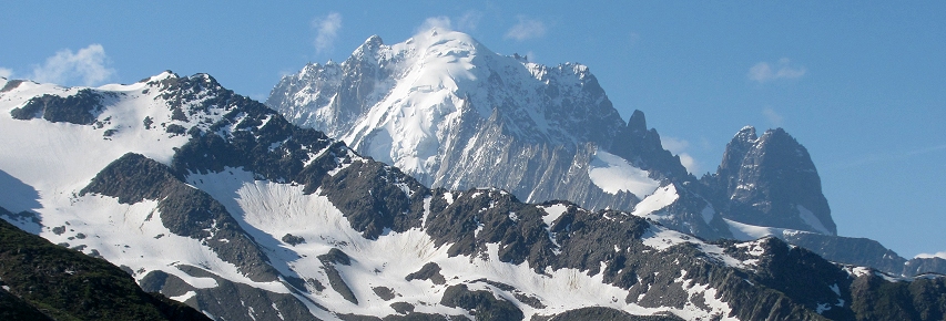
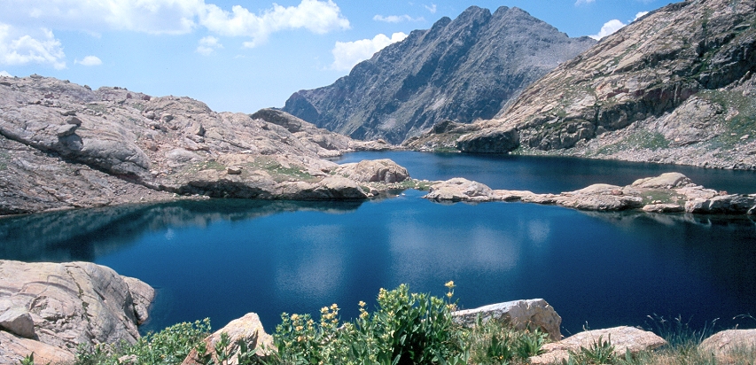
Mont Blanc, highest point in the Alps.
The Alps are the backbone of Europe and its principal and best-known mountain range. No peak in the Alps stands higher than Mont Blanc whose summit brushes the heavens at 15,772 feet. Thrust upward as result of a series of collisions between African and European plates, the Alps continue to grow today. They fan out in a great 750 mile-long arc around Italy’s Po River basin encompassing a multitude of ranges, each with its own character—from the Maritime Alps on the French-Italian border, to the rugged grandeur of Switzerland’s glacier-draped Berner Oberland, to the distinctive limestone spires and pinnacles of the Italian Dolomites. The range is named after the high mountain pastures known as alp in German. In turn, the range has lent its name to the adjective “alpine”—the general term used to describe high mountain environments anywhere in the world.
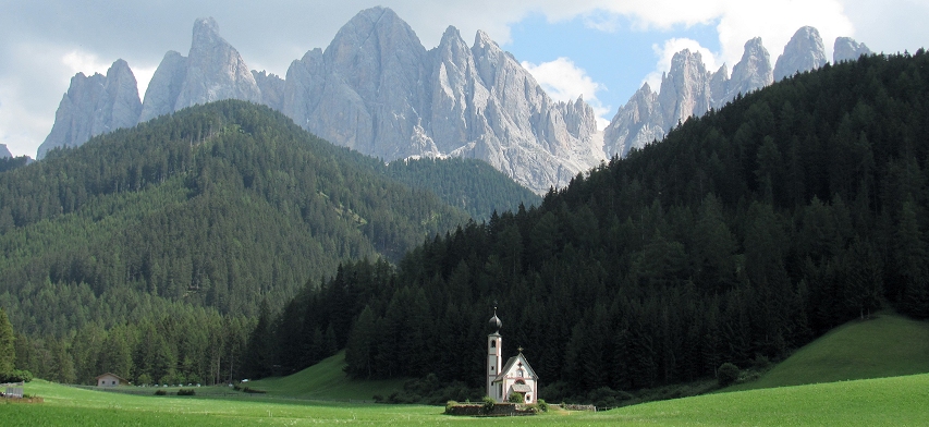
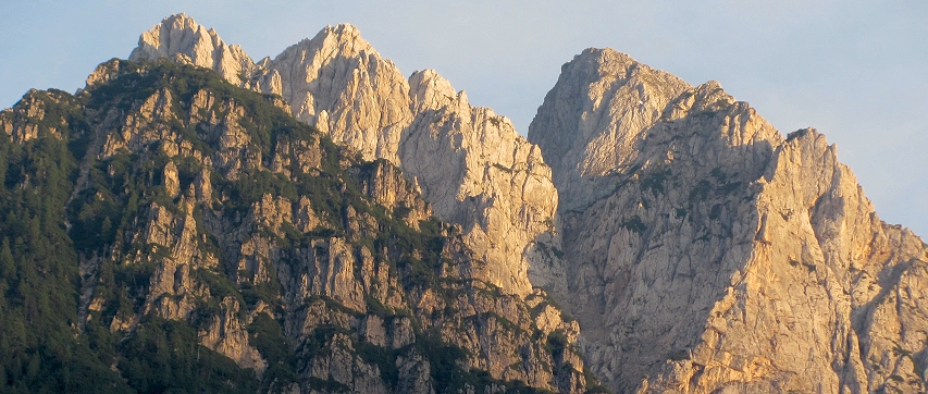
![]() The Dolomites of Italy. The graceful yet imposing spires and pinnacles of the Italian Dolomites rise above verdant meadows, deep forests, and valleys filled with alpine villages creating one of the most beautiful and intimate mountain landscapes on the planet. There is nothing anywhere that quite compares to the elegant forms of the peaks of the Dolomites! At first glance, the jagged silhouettes of these mountains might suggest that they are more the realm of mountaineers than of hikers. But amidst the jaw-dropping splendor of peaks winds a network of trails that caters to the full range of hiking abilities. Stroll across the Alpe di Siusi, one of Europe’s most extensive alpine meadowlands, or amble along paths that traverse ridgetops high above tree-line where 360-degree panoramas of a sea of peaks await. If you’re sure of foot and have a head for heights, you can attempt the Dolomites’ distinctive and challenging vie ferrate (“iron ways”) where cables and ladders bolted into the mountainside assist your passage.
The Dolomites of Italy. The graceful yet imposing spires and pinnacles of the Italian Dolomites rise above verdant meadows, deep forests, and valleys filled with alpine villages creating one of the most beautiful and intimate mountain landscapes on the planet. There is nothing anywhere that quite compares to the elegant forms of the peaks of the Dolomites! At first glance, the jagged silhouettes of these mountains might suggest that they are more the realm of mountaineers than of hikers. But amidst the jaw-dropping splendor of peaks winds a network of trails that caters to the full range of hiking abilities. Stroll across the Alpe di Siusi, one of Europe’s most extensive alpine meadowlands, or amble along paths that traverse ridgetops high above tree-line where 360-degree panoramas of a sea of peaks await. If you’re sure of foot and have a head for heights, you can attempt the Dolomites’ distinctive and challenging vie ferrate (“iron ways”) where cables and ladders bolted into the mountainside assist your passage.
The peaks of the Odle Geisler, Dolomites.
In the Dolomites, there are plenty of cable cars and chairlifts to give you a boost, and along the trail mountain huts (rifugi) await with cappuccino, minestrone, and apple strudel! Distinctive accommodations and warm hospitality are provided by innkeepers who speak Ladin—a language formed from the melding of Latin with the ancient languages of the mountain people. The Ladin language and culture are grace notes in the glorious symphony of landscape and people that is the Dolomites. Situated on the “sunny side of the Alps,” the Dolomites are a perfect choice for a first encounter with Europe’s mountains!
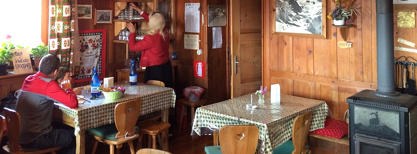
Inside a mountain rifugio in the Dolomites.
![]() The Swiss Alps. The Swiss Alps comprise perhaps the best known portion of the Alps. Everything quintessential about the Alps is found in the Berner Oberland and Valais—two of Switzerland’s best-known mountain regions. From ice-encrusted peaks to “story book” mountain hamlets surrounded by expansive, flower-filled meadow lands the Swiss Alps are a mountain hiker’s nirvana! A well-established and well-maintained trail network combined with a well-run mountain transport system (chairlifts, cog railways, and cable cars) means that hikers of all abilities from novices to experienced mountain walkers can have a rewarding experience of the Swiss Alps. Mountain huts and restaurants are well-managed and conveniently placed allowing you to indulge in a warm beverage, meal, or overnight stay amidst breathtaking mountain vistas!
The Swiss Alps. The Swiss Alps comprise perhaps the best known portion of the Alps. Everything quintessential about the Alps is found in the Berner Oberland and Valais—two of Switzerland’s best-known mountain regions. From ice-encrusted peaks to “story book” mountain hamlets surrounded by expansive, flower-filled meadow lands the Swiss Alps are a mountain hiker’s nirvana! A well-established and well-maintained trail network combined with a well-run mountain transport system (chairlifts, cog railways, and cable cars) means that hikers of all abilities from novices to experienced mountain walkers can have a rewarding experience of the Swiss Alps. Mountain huts and restaurants are well-managed and conveniently placed allowing you to indulge in a warm beverage, meal, or overnight stay amidst breathtaking mountain vistas!
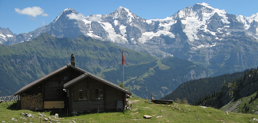
The Lobhornhütte backdropped by the Eiger, Mönch and Jungfrau, Berner Oberland, Switzerland.
![]() The Maritime Alps of France and Italy. At its western end on the border of France and Italy, the great Alpine arc meets the Mediterranean Sea. Here the Maritime Alps sometimes referred to in French as les Alpes Azures (the Azure Alpes) rise in jumbled splendor into the Mediterranean skies. The dry, herb-scented foothills of the Alps are punctuated by perched villages (villages perches) like Peillon which crowns the top of a rocky ridge. The core of the Maritime Alps is protected in the Mercantour National Park on the French side and in the Parco Naturale Alpi Marittime on the Italian side. Here in this untrammeled Alpine landscape you can experience a “wilder” version of the Alps. The Maritime Alps present hikers with all the elements of the classic alpine landscape (sparkling lakes, tumbling streams, flowery meadows, jagged peaks) but without the busy trails and recreational developments that characterize many of the more popular portions of the Alps. Sightings of large mammals like ibex and chamois are common, and there are stretches of trail where you may have the mountains entirely to yourself. Bronze Age petroglyphs decorate rock outcroppings in the Valley of Marvels (Vallée des Merveilles) and the Fontanalba Basin add another dimension to a Maritime Alps experience. And in the villages of the valleys, don’t forget to sample socca, a chick pea pancake baked in a wood-fired oven.
The Maritime Alps of France and Italy. At its western end on the border of France and Italy, the great Alpine arc meets the Mediterranean Sea. Here the Maritime Alps sometimes referred to in French as les Alpes Azures (the Azure Alpes) rise in jumbled splendor into the Mediterranean skies. The dry, herb-scented foothills of the Alps are punctuated by perched villages (villages perches) like Peillon which crowns the top of a rocky ridge. The core of the Maritime Alps is protected in the Mercantour National Park on the French side and in the Parco Naturale Alpi Marittime on the Italian side. Here in this untrammeled Alpine landscape you can experience a “wilder” version of the Alps. The Maritime Alps present hikers with all the elements of the classic alpine landscape (sparkling lakes, tumbling streams, flowery meadows, jagged peaks) but without the busy trails and recreational developments that characterize many of the more popular portions of the Alps. Sightings of large mammals like ibex and chamois are common, and there are stretches of trail where you may have the mountains entirely to yourself. Bronze Age petroglyphs decorate rock outcroppings in the Valley of Marvels (Vallée des Merveilles) and the Fontanalba Basin add another dimension to a Maritime Alps experience. And in the villages of the valleys, don’t forget to sample socca, a chick pea pancake baked in a wood-fired oven.
Lacs Bessons, Haut Boréon, French Maritime Alps.
![]() The Julian Alps of Slovenia. The mountains of Slovenia anchor the eastern end of the Alpine arc. The best known mountains in Slovenia are the limestone Julian Alps a compact group of peaks covering about 1,700 square miles. Most of the Julian Alps lies within Slovenia although about one third of the range actually lies in neighboring Italy. The Julian Alps reach their apex at the 9,400 foot summit of Mount Triglav. Picturesque Lake Bled (Blejsko jezero) as well as scenic Lake Bohinj (Bohinjsko jezero) serve as a jumping off points for hikes to Debela Pec, Triglav, the Valley of the Seven Triglav Lakes and other peaks in the eastern and southern Julian Alps. And the town of Kranjska Gora is a good staging point for hikes in the northwest of the range including the hike to the lovely meadows of Sleme beyond the Vrsic Pass. To the east of the Julian Alps lies the mountain plateau of Velika Planina, part of the smaller group of peaks known as the Kamnik Alps. The rolling meadows of the Velika Planina accented with traditional wooden huts and barns is somewhat reminiscent of the Alpe di Siusi in the Italian Dolomites.
The Julian Alps of Slovenia. The mountains of Slovenia anchor the eastern end of the Alpine arc. The best known mountains in Slovenia are the limestone Julian Alps a compact group of peaks covering about 1,700 square miles. Most of the Julian Alps lies within Slovenia although about one third of the range actually lies in neighboring Italy. The Julian Alps reach their apex at the 9,400 foot summit of Mount Triglav. Picturesque Lake Bled (Blejsko jezero) as well as scenic Lake Bohinj (Bohinjsko jezero) serve as a jumping off points for hikes to Debela Pec, Triglav, the Valley of the Seven Triglav Lakes and other peaks in the eastern and southern Julian Alps. And the town of Kranjska Gora is a good staging point for hikes in the northwest of the range including the hike to the lovely meadows of Sleme beyond the Vrsic Pass. To the east of the Julian Alps lies the mountain plateau of Velika Planina, part of the smaller group of peaks known as the Kamnik Alps. The rolling meadows of the Velika Planina accented with traditional wooden huts and barns is somewhat reminiscent of the Alpe di Siusi in the Italian Dolomites.
Golden light on the Julian Alps as seen from Kranjska Gora.
A view into the Dolina Pieciu Stawow Polskich (Valley of the Five Polish Lakes), High Tatras.
The Carpathian Mountains. Formed during the closure of an ancient sea, the Carpathian Mountains are essentially a continuation of the Alps although they are, in general, not as high or rugged. The great Danube River which drains much of central Europe separates the Alps from the Carpathians. The Carpathians run eastward for 900 miles along the Polish-Slovak border continuing into Ukraine and Romania where they abruptly hook back toward the west as the Carpatii Meridionali, or Transylvanian Alps. The High Tatras on the Polish-Slovak border constitute the highest and most rugged portion of the Carpathians. The highest point in the Carpathians, Gerlachovský Stít, scrapes the Tatra sky at 8,711 feet. Though they are longer in geographic extent than the Alps, the Carpathians are often overshadowed by their better-known neighbor, and their landscapes have remained largely unknown to most North Americans seeking to hike in Europe’s mountains.
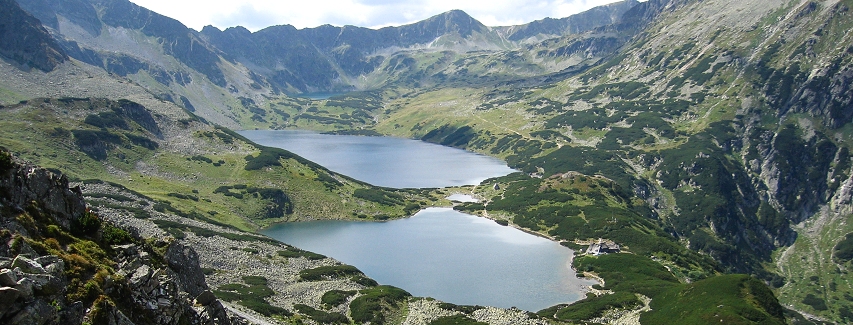
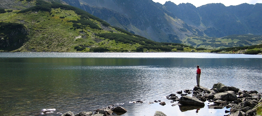
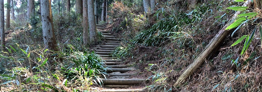
![]() The Bükk, Fatra, Slovensky Raj and Tatra Mountains. Just north of Budapest, the bucolic, gently rolling hills of northern Hungary mark the modest beginnings of the Carpathians as they begin their rise from the vast Hungarian plain (puszta). In Hungary, the best mountain hiking is in the Bükk National Park which protects a small densely forested range of karst (limestone) mountains punctuated by grassy, open meadows. Further north in Slovakia, the terrain rears up in the jumble of forested ridges that make up the Fatra Mountains and the karst range called the Slovensky Raj (Slovak’s Paradise) where ladders and boardwalks allow hikers access to the region’s narrow stream gorges. The Carpathian uplift culminates on the Slovak-Polish border in the dark, rocky, and majestic peaks of the Tatra Mountains, the highest and one of the very few truly alpine portions of the entire Carpathian mountain range. Here, glacier-carved crags soar above surrounding forests of beech, fir and spruce. This compact cluster of peaks is protected in national parks on both sides of the border and has been designated an international Biosphere Reserve. Many endemic, rare and protected species including the chamois, marmot, brown bear, falcon and golden eagle take refuge in the Tatras. Laboriously-built stone paths and stairways snake up into the mountains and comprise a significant portion of the Tatra Mountain trail network. Hiking routes are well established, signed and blazed. Mountain chalets (schronisko in Polish; chata in Slovak) are regularly encountered and offer meals and beverages to hikers.
The Bükk, Fatra, Slovensky Raj and Tatra Mountains. Just north of Budapest, the bucolic, gently rolling hills of northern Hungary mark the modest beginnings of the Carpathians as they begin their rise from the vast Hungarian plain (puszta). In Hungary, the best mountain hiking is in the Bükk National Park which protects a small densely forested range of karst (limestone) mountains punctuated by grassy, open meadows. Further north in Slovakia, the terrain rears up in the jumble of forested ridges that make up the Fatra Mountains and the karst range called the Slovensky Raj (Slovak’s Paradise) where ladders and boardwalks allow hikers access to the region’s narrow stream gorges. The Carpathian uplift culminates on the Slovak-Polish border in the dark, rocky, and majestic peaks of the Tatra Mountains, the highest and one of the very few truly alpine portions of the entire Carpathian mountain range. Here, glacier-carved crags soar above surrounding forests of beech, fir and spruce. This compact cluster of peaks is protected in national parks on both sides of the border and has been designated an international Biosphere Reserve. Many endemic, rare and protected species including the chamois, marmot, brown bear, falcon and golden eagle take refuge in the Tatras. Laboriously-built stone paths and stairways snake up into the mountains and comprise a significant portion of the Tatra Mountain trail network. Hiking routes are well established, signed and blazed. Mountain chalets (schronisko in Polish; chata in Slovak) are regularly encountered and offer meals and beverages to hikers.
In the basin of the Five Polish Lakes, High Tatras, Poland.
![]() The Bucegi, Fagaras, Piatra Craiului, and Retezat Mountains of Romania are the four principal subdivisions of the storied 225-mile-long Transylvanian Alps (Carpaţii Meridionali in Romanian). The eastern end of the Transylvanian Alps is anchored by the Bucegi Mountains known for their extensive, flower-spangled highland meadows and dramatic glacially-carved cirques. Nearby, the craggy, limestone “dragon-back” of the Piatra Craiului Mountains rise in counterpoint to the more massive silhouette of the Bucegi. Spruce forests and picturesque rural farmlands dominate the foothills of the Piatra Craiului. The central portion of the Transylvanian Alps is punctuated by the Făgăraş Mountains, perhaps the most distinctive (and quintessentially Romanian) portion of the range. Much of the high country of these mountains has been grazed for centuries and this is partly responsible for giving the mountains their scenic character. The open, grass-cloaked ridges and basins of the Făgăraş main ridge provide hikers with never-to-be-forgotten high country trail experiences! At the western end of the Transylvanian Alps rise the Retezat Mountains, perhaps Romania’s wildest and best-protected mountain massif. The area lies within a national park and has also been designated as a UNESCO Biosphere Reserve. Rugged and glacially-carved, the Retezat contains the greatest number of alpine lakes in the southeastern Carpathians.
The Bucegi, Fagaras, Piatra Craiului, and Retezat Mountains of Romania are the four principal subdivisions of the storied 225-mile-long Transylvanian Alps (Carpaţii Meridionali in Romanian). The eastern end of the Transylvanian Alps is anchored by the Bucegi Mountains known for their extensive, flower-spangled highland meadows and dramatic glacially-carved cirques. Nearby, the craggy, limestone “dragon-back” of the Piatra Craiului Mountains rise in counterpoint to the more massive silhouette of the Bucegi. Spruce forests and picturesque rural farmlands dominate the foothills of the Piatra Craiului. The central portion of the Transylvanian Alps is punctuated by the Făgăraş Mountains, perhaps the most distinctive (and quintessentially Romanian) portion of the range. Much of the high country of these mountains has been grazed for centuries and this is partly responsible for giving the mountains their scenic character. The open, grass-cloaked ridges and basins of the Făgăraş main ridge provide hikers with never-to-be-forgotten high country trail experiences! At the western end of the Transylvanian Alps rise the Retezat Mountains, perhaps Romania’s wildest and best-protected mountain massif. The area lies within a national park and has also been designated as a UNESCO Biosphere Reserve. Rugged and glacially-carved, the Retezat contains the greatest number of alpine lakes in the southeastern Carpathians.
Lacul Pietrele in the Retezat Mountains of Romania.
Mount Musala (right), the highest point in the Balkans.
The Balkans. The Carpathian Mountains meet the great mountainous uplift that covers much of the Balkan Peninsula at a place called the Iron Gates of Orsova. Here, the Danube River cuts through the mountain barrier before making its final run to the Black Sea. The Balkan uplift is composed of numerous mountain ranges most trending in a northwest to southeast direction. Included are the mountains of Croatia, Montenegro, Macedonia, Albania, Bulgaria, and Greece.
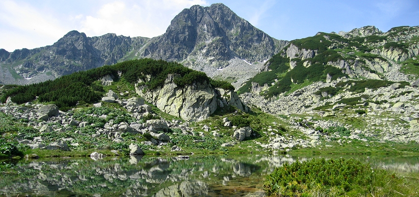
![]() The Rila, Pirin and Rodopi Mountains of Bulgaria. The Rila and Pirin ranges contain some of the most impressive high mountain landscapes remaining in Europe. Here you can find classical high country landscapes reminiscent of the Sierra Nevada or the Wallowas of northeastern Oregon. Musala in the Rila range rises above conifer-clad foothills to the roof of the Balkans at 9,597 feet (higher than Mount Olympus in Greece). Large portions of the Rila and Pirin ranges are protected in national parks. The Pirin National Park is a World Heritage Site containing the Baevi Doupki-Djindjiritza Biosphere Reserve. A third range which the Bulgarians call the Rodopi Mountains are lower, drier and less rugged than the Rila and Pirin ranges. Nevertheless, they are attractive in their own right offering pine-scented mountain walks through well-preserved traditional mountain villages. Mountain huts (called hizha in Bulgarian) can be found scattered through Bulgaria’s mountains. Many were first built in the 1950s when hiking was promoted as a patriotic endeavor! However, the standard of service and accommodation in the huts is not yet up to that of their Alpine counterparts.
The Rila, Pirin and Rodopi Mountains of Bulgaria. The Rila and Pirin ranges contain some of the most impressive high mountain landscapes remaining in Europe. Here you can find classical high country landscapes reminiscent of the Sierra Nevada or the Wallowas of northeastern Oregon. Musala in the Rila range rises above conifer-clad foothills to the roof of the Balkans at 9,597 feet (higher than Mount Olympus in Greece). Large portions of the Rila and Pirin ranges are protected in national parks. The Pirin National Park is a World Heritage Site containing the Baevi Doupki-Djindjiritza Biosphere Reserve. A third range which the Bulgarians call the Rodopi Mountains are lower, drier and less rugged than the Rila and Pirin ranges. Nevertheless, they are attractive in their own right offering pine-scented mountain walks through well-preserved traditional mountain villages. Mountain huts (called hizha in Bulgarian) can be found scattered through Bulgaria’s mountains. Many were first built in the 1950s when hiking was promoted as a patriotic endeavor! However, the standard of service and accommodation in the huts is not yet up to that of their Alpine counterparts.
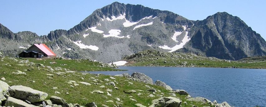
High country lake and hut in the Pirin Mountains of Bulgaria.
![]() The Velebit Mountains of Croatia. Croatia’s limestone Velebit Mountains are one of the most dramatic segments of the Dinaric Alps (also known as the Dinarides), a 400 mile long mountainous uplift that parallels the eastern coast of the Adriatic Sea. Portions of the Velebit Mountains are protected in the Paklenica and Sjeverni Velebit National Parks. A principal attraction for hikers in the Velebit Mountains is the 35-mile-long Premužićeva staza (Premužić Trail) which threads its way through the rugged karst topography of the Velebit. The trail was constructed as a Depression-era project in the early 1930s. Since 2009 the trail has been recognized as a nationally important cultural asset by the government of Croatia.
The Velebit Mountains of Croatia. Croatia’s limestone Velebit Mountains are one of the most dramatic segments of the Dinaric Alps (also known as the Dinarides), a 400 mile long mountainous uplift that parallels the eastern coast of the Adriatic Sea. Portions of the Velebit Mountains are protected in the Paklenica and Sjeverni Velebit National Parks. A principal attraction for hikers in the Velebit Mountains is the 35-mile-long Premužićeva staza (Premužić Trail) which threads its way through the rugged karst topography of the Velebit. The trail was constructed as a Depression-era project in the early 1930s. Since 2009 the trail has been recognized as a nationally important cultural asset by the government of Croatia.
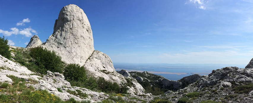
Kuk Stapina, a limestone monolith in the southern Velebit Mountains, Croatia.
![]() The Pindhos Mountains and Olimbos. The Pindhos Mountains (also spelled Pindos or Pindus) comprise the mountainous “spine of Greece” stretching 160 kilometers from southern Albania through the Grecian mainland to the Gulf of Corinth at the northern edge of the Peloponnese. The range separates the regions of Epirus (to the west) and Thessaly (to the east). The range reaches its high point at 8,652 foot tall Mount Smolikas. Composed largely of limestone, the landscapes of the Pindhos Mountains range from deep gorges and canyons (like the Vikos Gorge) to alpine meadows and craggy peaks. Lower elevations are cloaked in deciduous woodlands while coniferous woods featuring endemic species such as the Bulgarian fir (Abies borisii-regis) dominate the higher elevations. Two national parks—the Vikos-Aoos National Park and the Pindus National Park—protect the core of these mountains.
The Pindhos Mountains and Olimbos. The Pindhos Mountains (also spelled Pindos or Pindus) comprise the mountainous “spine of Greece” stretching 160 kilometers from southern Albania through the Grecian mainland to the Gulf of Corinth at the northern edge of the Peloponnese. The range separates the regions of Epirus (to the west) and Thessaly (to the east). The range reaches its high point at 8,652 foot tall Mount Smolikas. Composed largely of limestone, the landscapes of the Pindhos Mountains range from deep gorges and canyons (like the Vikos Gorge) to alpine meadows and craggy peaks. Lower elevations are cloaked in deciduous woodlands while coniferous woods featuring endemic species such as the Bulgarian fir (Abies borisii-regis) dominate the higher elevations. Two national parks—the Vikos-Aoos National Park and the Pindus National Park—protect the core of these mountains.
One of the best know areas in the Pindhos Mountains is the region known as Zagori (Zagorochoria, in Greek) northeast of the city of Ioannina, principal city of the Epirus region of northwestern Greece. Zagori (from the Slavic for “behind the mountains”) is known for its beautiful stone villages linked by old cobbled paths (called kalderimi in Greek) and picturesque humpbacked bridges. This network of paths provides nearly endless opportunities for hikers! Most villages are no more than a half day’s hike apart, so you can break your journey and enjoy refreshments (like an icy frappé) in the shade of a plane tree on a village square. More challenging hikes in the area include a rugged, day-long traverse along the floor of the spectacular Vikos Gorge or an ascent into the alpine country of the Timfi massif where the alpine tarn of Dhrakolimni (“Dragon’s Lake”) glimmers like a mountain jewel.
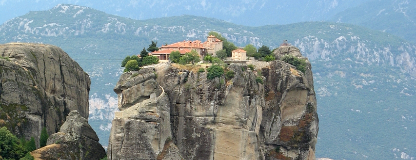
Holy Trinity Monastery, Meteora.
The sandstone monoliths of Meteora rise at the eastern edge of the Pindhos Mountains. Here, a cluster of soaring, monastery-crowned pinnacles of rock create one of Greece’s most recognizable and distinctive landscapes. Some of the old cobbled paths that once provided the only means of accessing the perched monasteries still thread their way among the rocks providing opportunities for adventurous hikers.
Perhaps Greece’s best known mountain is Mount Olympus (Oros Olimbos), a ten-mile-long range of peaks at the eastern edges of the Plains of Thessaly. Olympus is bordered to the east by the Aegean Sea whose shores sparkle only eleven miles from its summit. Olympus is the highest mountain range in Greece, and there are at least 46 peaks in the range that rise to an elevation of at least 2,000 meters (6,562 feet). The four highest peaks on Olympus are Mytikas (the highest at 9,571 feet), Skolio (at 9,551 feet), Stefani (at 9,544 feet and also known as the “throne of Zeus”), and Skala (at 9,403 feet). In mythology Mount Olympus was regarded as the home of the twelve principal gods of the ancient Greeks. Today, the area is protected in a national park. An ascent of Mount Olympus takes a minimum of two days (preferably three) with an overnight spent in a comfortable mountain refuge. A well-built trail ascends three thousand feet to the refuge situated just below the timberline. The following day, hikers continue along the trail that climbs the upper slopes of the mountain, sometimes steeply, to reach the top of Skala, one of several summits on Olympus.
The Mount Olympus massif.
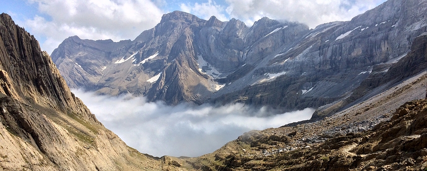
Cirque de Gavarnie near the Refuge Sarradets.
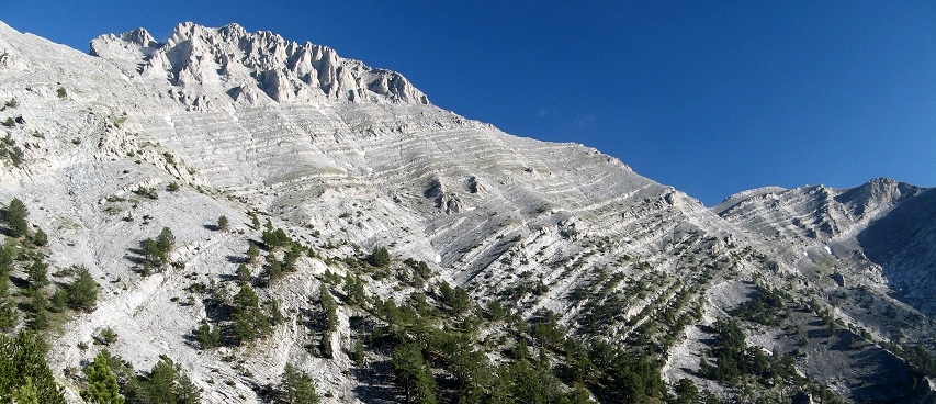
The Pyrenees. Stretching about 270 miles from the Atlantic Ocean to the Mediterranean Sea, the Pyrenees form a natural barrier between France and Spain. The Pyrenees easily rival the splendor of the Alps. They are wilder in character with a landscape less fragmented by villages and settlements than is the case in many parts of the Alps. About four thousand Pyrenean chamois, marmots, a dozen Pyrenean brown bears and the secretive desman (an aquatic mammal) are some of the wildlife species that call the Pyrenees home.
The highest and most dramatic peaks of the Pyrenees are found in the central portion of the range. Here, vast tracts of Pyrenean mountain splendor are protected in France’s Pyrenees National Park and Spain’s Ordesa Monte Perdido National Park. Grand glacial cirques and high lake basins are characteristic of the French side. In Spain, Monte Perdido, the highest limestone peak in Europe, soars to 11,008 feet, and the spectacular limestone canyon of Ordesa slices into the heart of the mountains. Further east, Spain’s Pico de Aneto reaches a Pyrenees high point at 11,168 feet. Much of the wild and rugged core of the central Pyrenees has been designated as a UNESCO World Heritage Site.
Within the national parks of the Pyrenees, the influence of human activity on the landscape has been minimized. There is consequently a general lack of “mountain transport infrastructure” (i.e. cable cars, chairlifts, etc.) in the prime hiking areas. Mountain huts are present in fair number, but they tend to be rustic when compared against their bretheren in the Alps. Large peripheral zones surround the national parks and are managed to maintain the pastoral economy and the life of the old mountain villages. Listen and you may sense the rich linguistic heritage of these mountains in the languages known as Euskara (Basque), Catalan, Occitan, Aranés, and Aragonés.
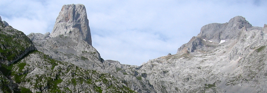
The Naranjo de Bulnes, emblem of the Picos de Europa.
The Cantabrian Mountains. The Cantabrian Mountains (the Cordillera Cantabrica) rise like ramparts for 300 miles along the northern coast of Spain, their feet washed by the surprisingly turquoise-colored waters of the Cantabrian Sea. The northern slopes of the mountains enjoy a maritime climate which has created a well-watered landscape often promoted as “Green Spain.” At their eastern end the Cantabrian Mountains merge gracefully with the Pyrenees.
South of the Basque city of Bilbao in the eastern Cantabrians, the mountain massifs of the Spanish province of Vizcaya rise like rocky islands above a multi-hued, patchworked sea of field and forest. Lesser-known hiking routes ranging from old tracks to rocky way trails ascend to the mountain heights from the villages below. In the rocky Urkiola massif rises the mystical peak of Anboto, home of a legendary Basque goddess. Some of the ridgetop hiking in this mountain group is reminiscent of an Irish “horseshoe walk.” Further to the south, hikers traverse the unfrequented grassy highlands atop the bulky sandstone summit of the Gorbeia Mountain at the southern edge of the Basque Cantabrians.
The crown of the Cantabrian Range is the small cluster of bulky limestone peaks known as the Picos de Europa (“Peaks of Europe”) allegedly named by mariners who sighted them before other landforms as they approached the European mainland by sea. The Picos de Europa are comprised of three massifs separated by deep, narrow gorges. (The Torre de Cerredo in the Urrieles massif of the Picos de Europa is the highest point in the Cantabrian Range at 8,688 feet.) The northern portion of the Picos is exposed to maritime influences and is consequently wetter than other portions of the range. Here, the generally rocky character of the Picos is tempered by the green high country meadows called vegas. Two lovely alpine lakes, a rarity in the Picos landscape, are also found in this area. Somewhat reminiscent of the Dolomites, the towering summits of the central Picos preside over trails that wind through a rocky, austere high country. A classic Picos de Europa hike is the vigorous trail ascent to the base of the Naranjo de Bulnes, an imposing, orange-streaked, limestone monolith. Equally enthralling is the hike through the Cares Gorge where a superbly maintained trail is etched into vertical canyon walls; it’s one of the finest canyon walks in Europe! Happily, much of the Picos de Europa is protected in Spain’s newly expanded Picos de Europa National Park.
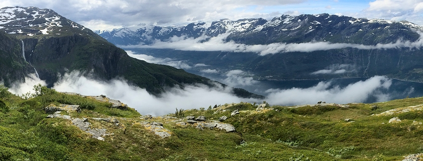
View from the Hardangervidda over the Sørfjord, Norway.
Scandinavia. The rocky range known as Kjølen (“the keel”) runs along the border between Norway and Sweden and forms the spine of the Scandinavian Peninsula. Part of the Caledonian Mountain Group (which includes the Scottish Highlands), Kjølen includes the mountainous uplift in Norway called Langfjellene (“Long Mountains”) crowned by the peak of Galdhopiggen (8,100 feet) in the Jotunehim (“Giant’s Home”) range. Ancient glaciers carved deep, steep-walled valleys into the seaward flanks of the Langfjellene. When the glaciers receded, the sea flooded the valleys to produce western Norway’s filigreed coastline and fjord-laced topography. Here, towering mountains plunge sharply into fjords that slice for hundreds of kilometers into the Langfjellene’s rocky core. Colorful villages huddle on rocky shorelines and isolated summer farms cling to shelves of land far above the fjords. Vantage points offering stunning views are a quintessential element of this near-vertical landscape. The blue glaciers descending from the Jostedalsbre, continental Europe’s largest icefield, remind you that the hand of ice is still at work on a landscape that some have called the most beautiful on earth!
The rugged nature of western Norway’s fjord country dictates the rugged nature of its mountain trails, and predictably “up” is a common direction for trails in Fjord Norway! Some of the most spectacular trail adventures in Fjord Norway are along the old, almost forgotten walking routes that once linked neighboring fjord valleys with one another. These more difficult hiking routes are often nothing more than “boot-beaten” paths delineated only by rock cairns or blazes, and a distinct trail tread is frequently absent. Vertical elevation gain can easily attain 3,000 vertical feet or more, but some of the wildest and most awe-inspiring mountain vantage points in Europe are the reward for such an effort. For wilderness-type solitude in Europe’s mountains, Fjord Norway may be the hiker’s best bet. It is not uncommon to hike for an entire day on some mountain routes and never meet another soul. If you’re seeking less difficult walks amidst the impressive physical geography of the fjords, a number of historic roads and pathways (now completely closed to vehicular traffic) provide less physically demanding (and sometimes nearly level) hiking options. On many of these routes (reminiscent of Irish bohereens), grass has grown over the old roadbeds making for pleasurable hiking.
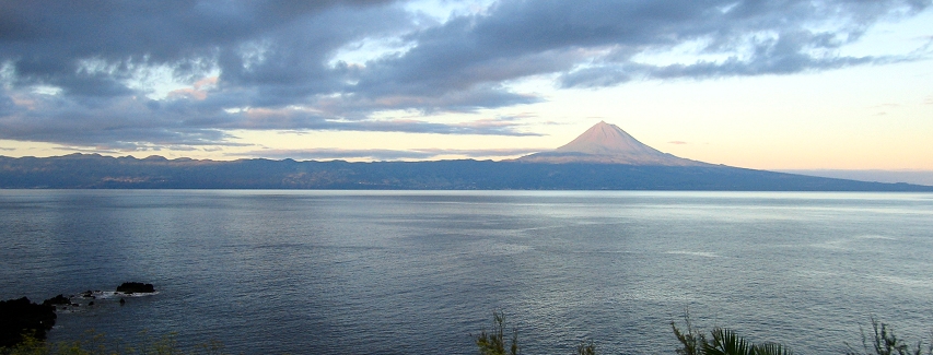
Pico volcano, highest point in Portugal, as seen from the neighboring island of São Jorge.
Macaronesia. The Azores along with the Madeira, Canary and Cabo Verde Islands are volcanic archipelagos that comprise the island region known as Macaronesia (“blessed islands”). The islands are the highest summits of great submarine mountain ranges that include the Mid-Atlantic Ridge, the world’s longest mountain range. Broad calderas, cone-shaped volcanoes, and plunging sea cliffs are typical of the Macaronesian landscape.
The Madeira and the Azores island groups belong to Portugal. In fact the highest mountain in Portugal is the Azorean stratovolcano, Pico (7,714 feet). These subtropical islands boast a wealth of endemic plant species as well as remnants of a forest type that covered much of southern Europe in the Tertiary age. These islands enjoy a sub-tropical climate and bear some physical resemblance to the islands of Hawaii. The verdant, sculpted cliffs of Madeira’s north slope are reminiscent of western Kauai while the lush highlands and volcanic cones of the Azores recall the landscapes of upcountry Maui or the Big Island.
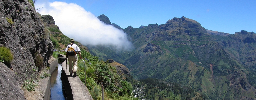
Hiking on the Levada das Rabaças, Madeira.
The Madeiran archipelago, which lies about 350 miles west of Morocco and 600 miles southwest of mainland Portugal, is made up of one principal island (Madeira), the smaller inhabited island of Porto Santo, and the uninhabited Ilhas Desertas. The levadas— narrow irrigation channels that were built as early as the 1500s to carry water from the highlands to drier parts of the island—are the defining feature of Madeiran hiking. (The word levada derives from the Portuguese word for “carry.”) Roughly 1600 miles of levadas traverse the island’s windswept moorlands and steep slopes. In some places, levadas have been “etched” across nearly vertical cliff faces. This engineering feat provides hikers with access to stunning mountain landscapes, some of which would be impossible to experience were it not for the levadas.
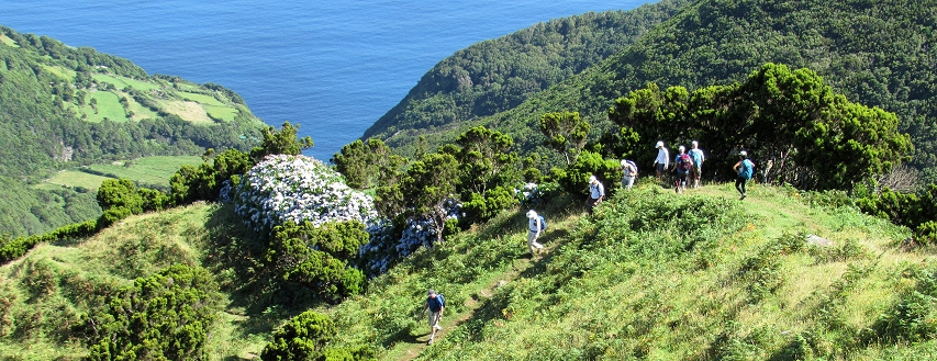
Hiking to the Fajã da Caldeira de Santo Cristo, São Jorge, Azores.
The Azores (Açores, in Portuguese), an archipelago of nine principal islands, lies about 900 miles due west of Lisbon. Lush, green, and largely un-touristed, the Azores present a variety of hiking experiences. Hikers can walk along the rim of vast volcanic calderas filled with crater lakes, ramble across extensive high country pasturelands crisscrossed by hydrangea hedgerows, and descend spectacular trails into steep-walled, emerald green valleys laced with waterfalls. The old cobbled paths that once were the only links between isolated coastal hamlets are now being marked and maintained for the pleasure of hikers.
|
|
| Japan and China |
|
|
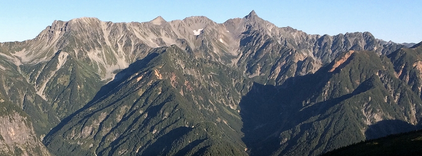
The Japan Alps from Chougatake.
The Japan Alps. The Japan Alps are composed of three ranges running roughly north-south in central Honshu, Japan’s main island: The Akaishi Range (also referred to as the Southern Alps or “Minami Arupusu” in Japanese); the Kiso Range (Central Alps or “Chūō Arupusu” in Japanese); and the Hida Range (also referred to as the Northern Alps, or “Kita Arupusu” in Japanese). The Northern Alps are arguably the most rugged and scenic of the three ranges. The Japan Alps are characterized by deep, steep-walled valleys and serrated ridgelines. Their upper reaches are rugged and alpine in character but lack the extensive high country lake basins found in in many other mountainous regions. The term “Japanese Alps” is said to have been coined by William Gowland, an English mining engineer who worked for Japan’s Meiji government in the late 1800s. At the close of the nineteenth century, the Reverend Walter Weston, an Anglican missionary, published the book, Mountaineering and Exploration in the Japanese Alps which did much to popularize hiking and climbing in Japan. Weston was also instrumental in the establishment of the Japanese Alpine Club, and a festival in his honor is held each June in Kamikochi.
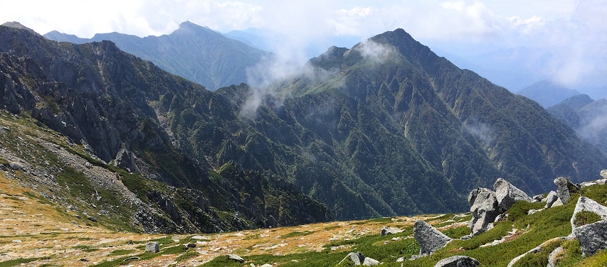
The Central Alps of Japan from the slopes of Kisokomagatake.
Hokkaido. Hokkaido is Japan’s northernmost island accounting for about twenty percent of the landmass of the Japanese archipelago. With the exception of the tectonically uplifted Yubari and Hidaka Ranges, Hokkaido’s mountains are the result of volcanic activity—not surprising since the entire island sits atop the Pacific “Ring of Fire.” The Ishikari Mountains, composed of the Daisetsuzan and Tomuraushi Volcanic Groups, are Hokkaido’s highest and most extensive mountain range. The range is dominated by the two-kilometer-wide Ohachi-daira caldera and the volcano Asahidake which is Hokkaido’s highest peak rising to an elevation of 7,516 feet. This mountain group is known for its fine displays of alpine wildflowers like those which blanket the slopes of Midoridake in spring. Other important volcanic ranges on Hokkaido include the Niseko Volcanic Group (Niseko-kazangun) lying forty miles to the southwest of Sapporo and protected in Shikotsu-Toya National Park. These highlands are composed of ancient stratovolcanoes and lava domes which last erupted seven thousand years ago. Here is a mountain landscape which some have called the “St. Moritz of the East.” About eighty miles to the east of the Daisetsuzan lies the Akan Volcanic Complex in Akan National Park. The complex includes the active Meakan-dake volcano. Nearby are the large and scenic caldera lakes of Kussharo and Mashu. About seventy miles to the northeast on the Shiretoko Peninsula (Shiretoko-hanto), a line of volcanic peaks juts for about forty miles into the Sea of Okhotsk. This line of mountains along with the neighboring Kuril Islands is part of the Chishima island arc. The Shiretoko Peninsula is one of the most pristine natural areas in Japan and is a designated national park and World Heritage Site. Though they may not be as high as some of the ranges on Japan’s main island of Honshu, Hokkaido’s mountain ranges offer hikers some of the best volcanic mountain landscapes in the world!
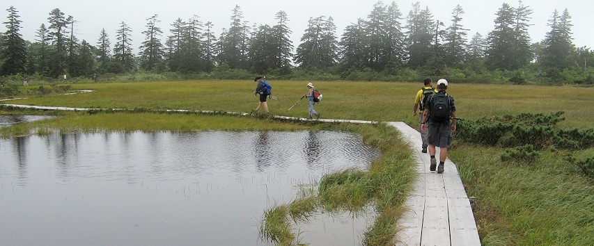
Boardwalk trail at Shinsen-numa, Hokkaido.
Well-marked and well-constructed paths are typical in the most popular hiking areas on Hokkaido such as Shinsen-numa in the Niseko Highlands (where boardwalks lead you through lovely wetlands) and at the Sugatami Ponds in the Daisetsuzan National Park. Trail conditions typically become more challenging as you proceed into more remote areas. Fast-growing dwarf bamboo, Japanese stone pine (Pinus pumila) and mountain birch sometimes crowd less frequently traveled mountain trails but these do not present obstacles for careful and attentive hikers. There are well-developed trails to the summits of several volcanoes on Hokkaido; some of these paths are steep, but others such as the trail to the top of active Tarumae-san volcano are well within the grasp of beginning mountain hikers. The thrill of standing atop an rumbling, steaming active volcano is not soon forgotten! Chairlifts and cable cars (called “ropeways” in Japan) provide access to high mountain trailheads in Daisetsuzan National Park and in a few locations in the Niseko area. Hikes with large elevation gains can be expected in much of the wild Shiretoko National Park where lifts and ropeways are notably absent.
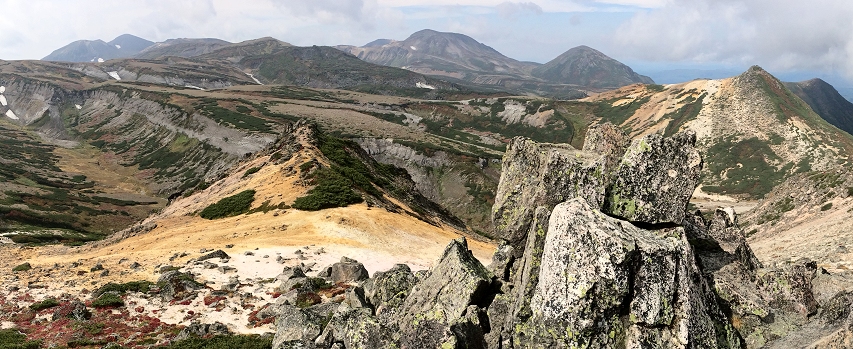
The volcanic high country of Daisetsuzan National Park, Hokkaido.
Shikoku. Shikoku is the smallest of Japan’s four major islands. It covers an area slightly larger than the states of Connecticut and Rhode Island combined. Ishizuchi-san (“stone hammer”), the tallest peak in western Japan dominates Shikoku’s mountainous interior. For walkers and hikers, Shikoku’s biggest draw is the 88 Temple Pilgrimage (Hachiju-hachi kasho meguri), a 700-mile circular pilgrimage route around the island which has its origins in the twelfth century. The pilgrimage revolves around the life’s work of the Buddhist monk Kukai who became known posthumously as Kobo Daishi (dharma master). He was responsible forbringing Shingon Buddhism to Japan from China. Portions of the original pilgrimage route pass through Shikoku’s mountains presenting attractive hiking opportunities to those who love to explore the mountains. Because the pilgrimage route has been well-traveled for centuries, the pilgrimage trails tend to be among the best constructed and maintained trails in the mountains of Japan.
The trail ascending to the mountain temple of Yokomine.
Yan Mountains, China. The Yan Mountains (or Yān Shān in Chinese) rise to the north of the North China Plain in northern Hebei Province. The mountains stretch for about 200 miles from the Chaobai River on the west to the Bohai Sea on the east. Beijing lies to the south of the range. The range reaches its highest point at Mount Wuling which rises to almost 7,000 feet above sea level and serves as the centerpiece of the Mount Wuling Nature Reserve. The eastern portions of the Great Wall of China traverse the Yan Shan and provide hikers with a great avenue for exploring the limestone, basalt and granite peaks of this lesser known Chinese mountain range.
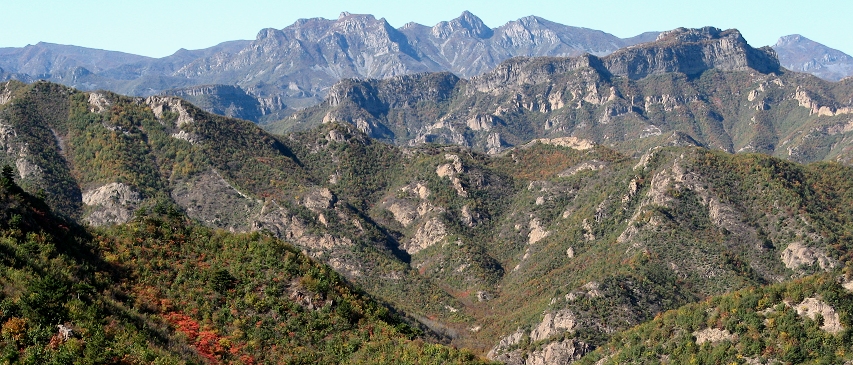
The Yan Mountains in the fall seen from the Dongjiakou Great Wall.
Hiking along the Great Wall is a varied experience and by no means a monotonous exercise! In some places you’ll walk on beautifully restored sections of wall built during the Ming Dynasty. In other places, like Dongjiakou, the wall is “wilder” and vegetation softens its contours. In some areas the wall is simply a trace of stones winding through the woods largely reclaimed by time and nature. Sometimes you’ll walk atop the wall itself, and at other times you’ll walk alongside it on a hiking trail. In certain areas you can leave the wall entirely to pursue a alternative route through remote valleys and villages before rejoining the wall at a later point. As you hike along the wall, you’ll encounter stairways, ramps, watchtowers, and occasional short ladders. In some places cable cars can be used to access trailheads atop the wall. It’s possible to avoid the sections of wall that attract the crowds so you can enjoy blissful moments of near-solitude on the Great Wall! Throughout your journey you’ll enjoy the landscapes of China that unfold around you from small villages where oxen are still used to plow the fields to remote mountain ridges where the views extend for miles!
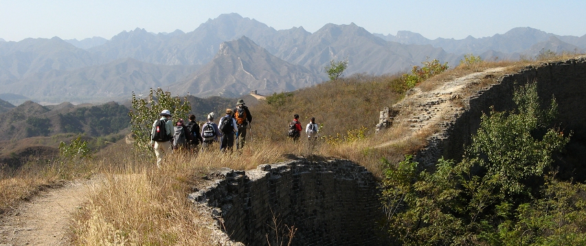
Hikers on the Great Wall near Gubeikou.
|
|
| South America |
|
|
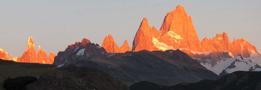
Sunrise on the Fitzroy massif near El Chalten, Argentine Patagonia.
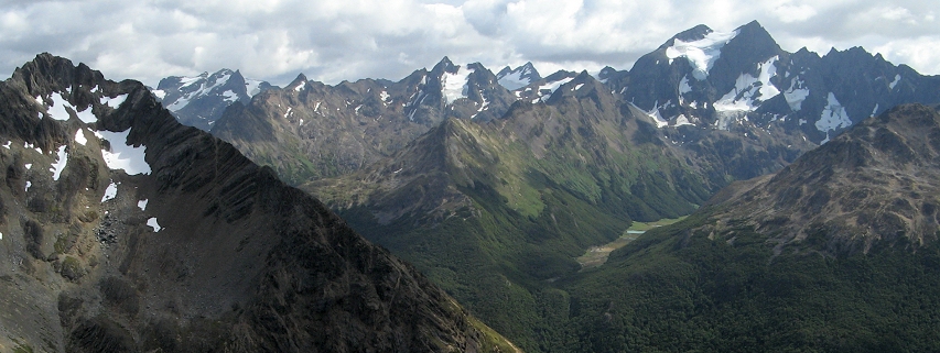
The Patagonian Andes Patagonia is a geographic region encompassing the southernmost portion of the South American continent and is shared by Chile and Argentina. The mountainous spine of the Patagonian Andes, the southern extent of the Andes Mountains, stretch for about 1,300 miles in the western portion of the region. To the west, Chilean Patagonia is mountainous with extensive forests, large lakes, fjords, and a damp, maritime climate. Argentine Patagonia, by contrast, consists largely of broad, semi-arid steppes that extend from the Atlantic coast eastward for about 300 kilometers where they meet the abruptly rising peaks of the Patagonian Andes. The highest peak in the Patagonian Andes is Volcan Domuyo rising to an elevation of 15,450 feet in the northern part of the range in Argentina’s Neuquen province. The southern Patagonian Andes is capped by Monte San Valentin, a remote ice-clad peak in Chile’s Aisén region which rises to an elevation of 13,314 feet (although some claims place the peak’s elevation several hundred feet lower).
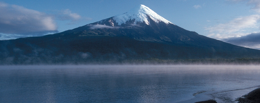
Volcan Osorno rises above Lago Llanquihue, Chilean Patagonia.
The northern portion of the Patagonian Andes (between roughly 37 and 42 degrees south latitude) is generally known as the Lake District comprised of the regions of Araucania and Los Lagos in Chile and portions of Santa Cruz, Rio Negro and Neuquen provinces in Argentina. Largely reminiscent of the Pacific Northwest, snow-capped volcanoes (some still active), large lakes, rushing streams and dense forests of southern beech characterize this area. A popular base for exploring the Lake District is the Argentine town of San Carlos de Bariloche sitting at an elevation of about 2,500 feet on the shores of immense, fjord-like, mountain-ringed Nahuel Huapi Lake. Much of the surrounding mountains falls within the boundaries of the Nahuel Huapi National Park. General elevations are not high when compared against, for example, the Peruvian Andes. Ridges in the Nahuel Huapi area top out at an average of 6,500 feet (roughly the elevation of Timberline Lodge on Oregon’s Mount Hood) with high country lake basins nestling in at the 5,500 foot level. Reaching the area’s high country lake basins on foot often involves somewhat long approaches up southern beech forested valleys like the Arroyo Van Titter and Arroyo Goye, but the high country splendors that await are reward enough for the effort! A few mountain refuges, notably the Refugio Lopez and Refugio Frey, provide hikers with shelter from the vagaries of Patagonia’s unpredictable weather.
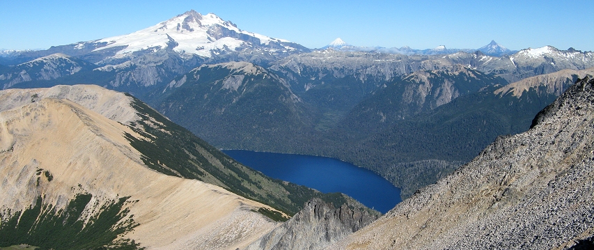
Volcan Tronador (left) and the waters of Brazo Tristeza, an arm of Lago Nahuel Huapi, Argentine Patagonia.
Between roughly 42 and 46 degrees south latitude in Chile is a wild, sparsely settled region whose western coastline is a twisted maze of channels, islands, and fjords similar to southeast Alaska. Wild rivers like the Futaleufu tumble to the sea and remote volcanoes occasionally erupt as did Volcán Chaitén in 2008 and Volcán Hudson in 1991.
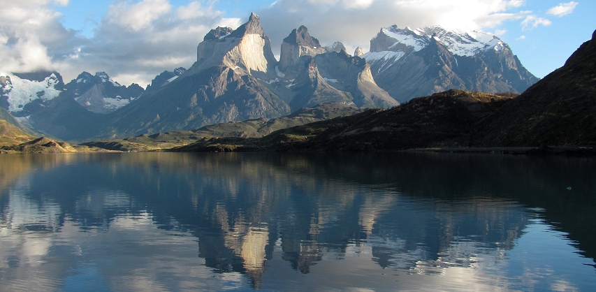
A rare wind-free morning in Patagonia produces glorious reflections of the Cuernos del Paine in Lago Pehoe.
In Southern Patagonia (south of 46 degrees) the Andes increase in average elevation and craggy peaks begin to replace snowcapped volcanic cones. The Patagonian icecap composed of the (Campo de Hielo Norte and the Campo de Hielo Sur) dominates the mountains and forms the largest expanse of ice outside the polar regions. Giant glaciers spill into vast, turquoise-colored lakes, and the iconic granite spires of Patagonia—Cerro Torre, Monte Fitzroy and the Torres del Paine—pierce the southern skies. The weather in this region can be notoriously inclement, but despite this reality the region is a paradise for hikers.
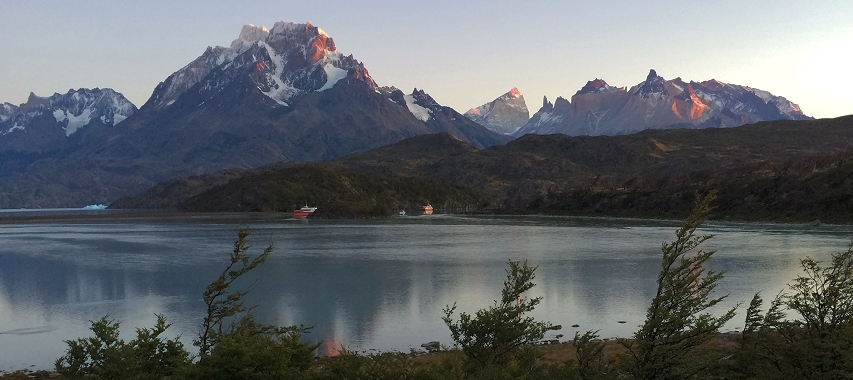
Paine Grande (left) towers almost ten thousand feet above the surface of Lago Grey, Chilean Patagonia.
The skyscraping peaks of Monte Fitzroy and the Torres del Paine have come to symbolize southern Patagonia. These rocky towers rise in spectacular topographic abruptness from their bases. Monte Fitzroy, for example, rises almost 10,000 vertical feet from the valley floor of the Rio de las Vueltas which lies only seven and a half miles from its summit. And the peak of Paine Grande in Chile’s Torres del Paine National Park rises 10,000 vertical feet from Lago Nordenskjold which lies only four miles from its summit. At first glance, these soaring pinnacles suggest a land of rugged hiking suitable only for experienced mountain hikers. However, the reality is that many trails traverse the rolling terrain at the base of these peaks, so the hiking is not, in general, as difficult as the rugged forms of the peaks might tend to suggest. Well-built trails wind their way through a landscape of southern beech woodlands, broad river valleys and the grassy wetlands known as in Patagonia as mallín. This topographically accessible landscape nevertheless provides stunning, close-up views of the granite spires of the Patagonian Andes. In the Fitzroy area most of the hikes takes place at elevations between 1,300 and 2,500 feet. Optional ascents to viewpoints at Pliegue Tumbado and Laguna de los Tres require additional elevation gain. In Torres del Paine National Park in Chile, most of the principal day-hikes start at very low elevations—between 200 and 400 feet above sea level.
The Cordillera Vinciguerra, Tierra del Fuego, Argentina.
Further south on the island of Tierra del Fuego, the Fuegian Andes rise in the jumble of ice-clad peaks known as the Cordillera Darwin. Broad, glacially-carved valleys penetrate the range which offers some of the wildest and challenging trekking opportunities in the Andes. The Fuegian Andes reach their high point at Mount Darwin which rises to an elevation of 8,163 feet in Chilean Tierra del Fuego. Across the waters of the Beagle Channel, the wild, untrammeled mountain landscapes on virtually uninhabited Isla Hoste call to only the most adventurous.
|
|
| Australia |
|
|
Blue Lake, Snowy Mountains, Kosciuszko National Park, Australia.
The Australian Alps comprise the highest portion of eastern Australia’s continent-long Great Dividing Range—a complex of mountain ranges that extends for 1,900 miles from the Grampians in western Victoria state to Queensland in the north. Though the Australian Alps lack the jagged summits, height and steep slopes of their European namesake they are a notable topographic exclamation mark for Australia, a relatively flat and low-lying continent.
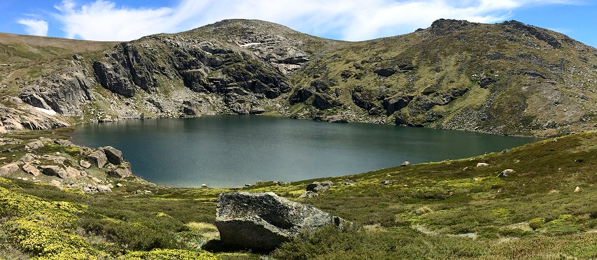
The highest portion of the Australian Alps center around the granite summits of the Main Range, part of the Snowy Mountains protected within the Kosciuszko National Park in New South Wales. Here, mainland Australia’s only glacially-carved cirques and alpine tarns can be found. The rounded forms and rock-strewn summits of Kosciuszko National Park recall the peaks of the White Mountains of New Hampshire or those of Connemara in western Ireland. The centerpiece of Kosciuszko National Park is 7,310-foot-tall Mount Kosciuszko, the tallest peak on the Australian continent. The peak was named by Polish explorer Paul Edmund Strzelecki in 1840 after the mountain’s resemblance to the Kosciuszko Mound in Krakow, Poland—a monument constructed to commemorate the accomplishments of Polish patriot Tadeusz Kosciuszko who served as a general in the the Continental Army during the American Revolution.
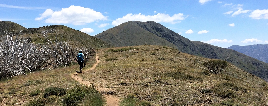
Trail to Mount Feathertop in the Victorian Alps, Alpine National Park, Australia.
Unlike the granitic Main Range, the Victorian Alps of Victoria state are largely composed of sedimentary rocks. Long ridges with interlocking spurs and rolling high plateaus are characteristic of the Victorian Alps. A notable feature of these mountains are the Bogong High Plains, a high elevation plateau formed by ancient basalt flows and covered by alpine herbfields and tussock grasslands.
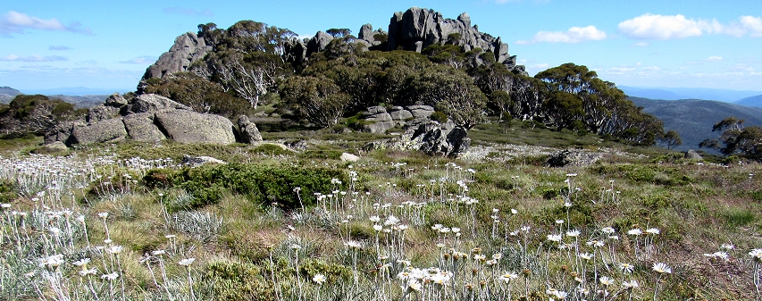
A trio of national parks— Namadgi, Kosciuszko and Alpine—provide protection to a significant portion of the Australian Alps.
High country landscape, Kosciuszko National Park, Australia.
Photos on this page are by John Osaki (© All Rights Reserved) except as otherwise credited.