Trail Samplers
On our hiking trips we offer at least two guided hiking options on each hiking day. To give you a better sense for what the hiking options are like on a Mountain Hiking Holidays trip, we’ve prepared the following Trail Samplers for our most popular tours. If you need additional information about hiking distances and elevation gains/losses involved on any of our currently operating trips, please let us know.
Please note that the following are examples of the hiking options we offer on our trips. The actual distances and elevation gains and losses associated with the shorter and longer hiking options on each of our trips will vary from day to day and destination to destination based on specific topography and trail conditions.

Dolomites Trail Sampler
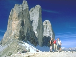 Tre Cime from Paternsatel.
|
SHORTER OPTION Rifugio Locatelli Start: Rifugio Auronzo Destination: Rifugio Locatelli End: Rifugio Auronzo Estimated time: 3-4 hours round trip Elevation gain/loss: 1,100 feet of gain / 1,100 feet of loss Highest point: 8,050 feet Total distance: Approximately 6 miles round trip |
| Start this hike at Rifugio Auronzo, elevation 7,612 feet. The first mile or so to the Rifugio Lavaredo is on a wide gravel path which contours at the base of the magnificent rock spires of the Tre Cime di Lavaredo. From Rifugio Lavaredo, weather permitting, there are views south to the sharp peaks of the Cadini mountain group. All around you rise the pinnacles and ridges of the Sesto Dolomites. The Rifugio Lavaredo serves beverages, soup, and light meals. Restrooms are also available. From the Rifugio Lavaredo, the trail narrows slightly and ascends at a gentle grade to the broad pass known as the Paternsatel (or Forcella di Lavaredo) which separates the Tre Cime from Monte Paterno. From the Paternsatel, you can see your destination, Rifugio Locatelli, at 7,999 feet. The well-graded trail descends from the Paternsatel and contours around the base of Monte Paterno and then climbs gently to Rifugio Locatelli. Rifugio Locatelli serves beverages, soup, and light meals. Return to Rifugio Auronzo by retracing your steps. | |
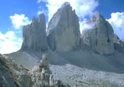 Tre Cime di Lavaredo.
|
LONGER OPTION Monte Paterno Circuit Start: Rifugio Auronzo Destination: Loop hike around Monte Paterno End: Rifugio Auronzo Estimated time: 7 hours Elevation gain/loss: 2,000 feet of gain / 2,000 feet of loss Highest point: 8,300 feet Total distance: Approximately 9 miles |
| One of the classic hikes in the Dolomites amidst some of the finest scenery these mountains have to offer. This is a strenuous hike and involves a full day on the trail. Follow Option 2 as far as Rifugio Locatelli, 3.5 kilometers from the start. From Rifugio Locatelli, contour along the north slope of Monte Paterno past the tarns known as the Bödenseen on a narrow but, well-beaten footpath. The path then begins a rocky, steep climb to the pass known as the Forcella Pian di Cengia (Büllelejoch). From the pass, a short detour will take you to the Rifugio Pian di Cengia with views of the massive peak called the Zwolferkofel. From there, the trail descends in sweeping curves and switchbacks into a basin containing the shallow tarns of the Laghi di Cengia. The trail continues its descent, then contours through sloping meadows before climbing stiffly to the Rifugio Lavaredo where the “loop” is closed. From Rifugio Lavaredo, an easy mile will return you to the starting point at Rifugio Auronzo. | |
Pyrenees Trail Sampler
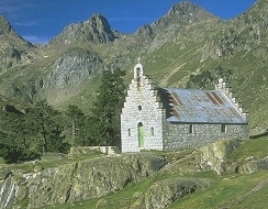 Chapel near Refuge Wallon.
|
SHORTER OPTION Refuge Wallon Start: Pont d’Espagne Destination: Refuge Wallon End: Pont d’Espagne Estimated time: 4-5 hours round trip Elevation gain/loss: 1,350 feet of gain / 1,350 feet of loss Highest point: 6,120 feet Total distance: Approximately 7.5 miles |
| Start this hike just below Pont d’Espagne at 4,787 feet elevation. The first 0.5 mile, or so, to the Chalet du Clot (4,994 feet) is on a small service road. From the Chalet du Clot, cross the meadow to the right to find the old path that continues up valley on the left bank of the Gave du Marcadau (stream). The trail traverses lush meadows punctuated by tall pines. Straight ahead, enjoy fine views up the valley toward the peaks on the Spanish border. The path reaches the Pont du Cayan (5,381 feet) about two miles and one hour from the start of the hike. Cross the bridge and continue up the valley, climbing now on a rough jeep track which eventually becomes trail, to Refuge Wallon, about 3.75 miles from the start. Refuge Wallon sits amid grassy meadows, laced by winding streams and picturesque clumps of pine. Refuge Wallon intermittently serves beverages, soup, and light meals. Retrace your steps to return to the starting point. | |
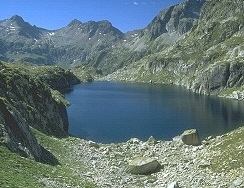 Lac Nère.
|
LONGER OPTION Marcadau Lakes Circuit Start: Pont d’Espagne Destination: Loop hike via Lac du Pourtet, Lac Nère and Refuge Wallon End: Pont d’Espagne Estimated time: 9.5 hours Elevation gain/loss: 3,200 feet of gain / 3,200 feet of loss Highest point: 8,000 feet Total distance: Approximately 12 miles |
| A long day on the trail but a superb and highly scenic journey recognized as one of the classic walks of the Pyrenees. Follow the route for Option 1 as far as Refuge Wallon. From Refuge Wallon, a well-graded, sometimes rocky mountain trail ascends 1,450 feet through pines and alpine meadows to beautiful rock-rimmed Lac Nère (7,576 feet), 1.5 hours walking from Refuge Wallon. The trail continues its climb, winding through a rocky landscape, to the highest point on the route, Lac Pourtet at 7,940 feet (40 minutes walk from Lac Nère). From Lac Pourtet, the trail descends a valley (sometimes steeply) past the the string of lakes known as the Lacs de l’Embarrat and in 2.5 hours arrives at the Pont du Cayan from where you can follow either the left or right banks of the Gave du Marcadau back to the starting point. | |
Patagonia Trail Sampler
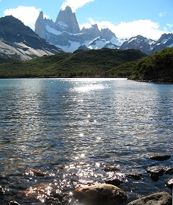 Monte Fitzroy from Laguna Capri.
|
SHORTER OPTION Laguna Capri Start: El Chalten Destination: Laguna Capri End: El Chalten Estimated time: 4 hours round trip Elevation gain/loss: 1,200 feet of gain / 1,200 feet of loss Highest point: 2,500 feet Total distance: Approximately 5 miles round trip |
| From the northern end of the town of El Chalten, a well-built trail ascends along the course of the stream called the Chorillo del Salto to Laguna Capri, one of the most beautiful spots in Argentina’s Los Glaciares National Park. From the shores of this lake the view of Monte Fitzroy and its entourage of surrounding peaks is picture postcard perfect. Take time to enjoy the beauty of this place before retracing your steps to El Chalten. | |
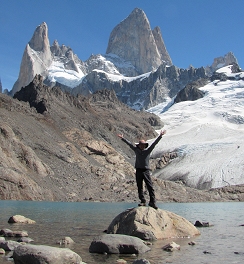 Monte Fitzroy, Laguna de los Tres.
|
LONGER OPTION Laguna de los Tres Start: El Pilar Destination: One-way hike to El Chalten via Laguna de los Tres End: El Chalten Estimated time: 8-10 hours Elevation gain/loss: 2,500 feet of gain / 2,300 feet of loss Highest point: 3,850 feet Total distance: Approximately 12.5 miles |
| From the trailhead at El Pilar, proceed up the valley of the Rio Blanco and enjoy wonderful views of the Piedras Blancas Glacier and Lake en route. From the climber’s camp at Campamento Rio Blanco ascend a steep, switchbacking trail to the shores of the Laguna de los Tres. On a clear day, the view of the Fitzroy massif across the waters of this small lake are nothing short of breathtaking. After soaking in the views, retrace your steps down the switchbacks to Campamento Rio Blanco. From here, the trail winds past small ponds and wetlands (known in Patagonia as mallin) leading you eventually to the shores of lovely Laguna Capri. From Laguna Capri, the trail makes a steady descent into the valley of the Rio de las Vueltas bringing you to the town of El chalten where the hike ends. | |
Iceland Trail Sampler
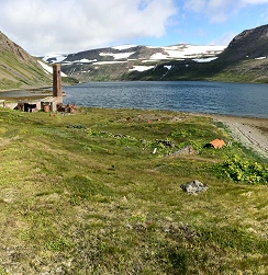 Old whaling station, Stekkeyri.
|
SHORTER OPTION Hesteyri and Stekkeyri Start: Hesteyri Destination: Stekkeyri End: Hesteyri Estimated time: 4 hours round trip Elevation gain/loss: 100 feet of gain / 100 feet of loss Highest point: 2,500 feet Total distance: Approximately 5.4 miles round trip |
| This hike starts with a boat ride from Ísafjörður to the mostly abandoned settlement of Hesteyri in the Hornstrandir Nature reserve, From Hesteyri, hike northward alond the shore of the Hesteyrifjörður to the old Norwegian whaling station about at Stekkeyri. The whaling station was in operation from 1894 to 1915. Todya, only ruins of a former herring processing plant stand in lonely windswept solitude at Stekkeyri. Retrace your steps to Hesteyri and then continue southward along the sandy shoreline of the fjord for as far as you desire, or until you meet the trail from Aðalvik descending from the mountains. Return to Hesteyri on foot where you’ll catch the ferry back to Ísafjörður. | |
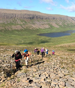 Trail to Hesteyri, Hornstrandir.
|
LONGER OPTION Aðalvik to Hesteyri Start: Aðalvik Destination: One-way hike to Hesteyri via the Fannadalslaegðir End: Hesteyri Estimated time: 6-7 hours Elevation gain/loss: 1,000 feet of gain / 1,000 feet of loss Highest point: 900 feet Total distance: Approximately 9.7 miles |
| Travel by boat to the large bay of Aðalvik in the Hornstrandir Nature Reserve, site of the now abandoned settlement of Saebol. From here, hike up-valley (passing an old church en route) and ascend into the low mountains behind Aðalvik. From the mountains, enjoy views across the waters of the Jökulfirðir (“glacier fjords”) to the ice of the Drangajökull, the lowest-lying glacier in Iceland. Savor the wild landscapes before descending to Hesteyri, another mostly abandoned settlement near the mouth of the fjord called the Hesteyrifjörður. Travel by boat back to Isafjörður. | |
Bulgaria Trail Sampler
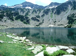 Ribno Ezero (Fish Lake).
|
SHORTER OPTION Ribno Ezero & Dûlgo Ezero Start: Vihren Chalet Destination: Bûnderishki Ezera (Bûnderishki Lakes) End: Vihren Chalet Estimated time: 3.5 to 4 hours round trip Elevation gain/loss: 1,250 feet of gain / 1,250 feet of loss Highest point: 7,630 feet Total distance: Approximately 4 miles round trip |
| Enjoy this exploration of the verdant landscapes of the Bûnderitsa Valley. From road’s end at the Vichren Chalet (6,398 ft) the trail leads along the Bûnderitsa stream passing through green, well-watered meadows punctuated by large granite boulders. About 1 hour from the start, the trail reaches the Ribno Ezero (“Fish Lake”), the largest of the Bûnderishki Lakes (Bûnderishki Ezera), cupped in the headwall of the lower Bûnderishki Cirque. Continue ascending steadily but gradually into the upper Bûnderishki Cirque to arrive at the Dûlgo Ezero (“Long Lake”), the largest lake in the upper cirque and a great turnaround point for a day’s outing in the mountains. Pick out a picnic spot among the clumps of mugo pine and granite boulders that line the lakeshore. Enjoy the play of light and shadow across the cobalt waters of the lake and the high peaks beyond! Retrace your steps to the starting point. | |
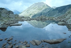 Reflection of Malka Todorka.
|
LONGER OPTION Valyavitsa Valley via Todorina Porta Start: Vihren Chalet Destination: Through hike to the Valyavitsa Valley via the Bûnderishki and Vasilashki Lake basins End: Valyavitsa Valley Estimated time: 5.5 to 6 hours Elevation gain/loss: 2,000 feet of gain / 3,500 feet of loss Highest point: Todorina Porta (8,400 ft) Total distance: Approximately 11.5 miles |
| If you’re in for more of a workout, try a mountain crossing from one valley to the next! Follow Option 1 as far as Dûlgo Ezero from where a switchbacking trail ascends to the summit of the pass known as Todorina Porta (8,400 ft). The trail then descends into the Vasilashki Cirque passing a couple of mountain lakes before reaching the Demyanitsa Chalet deep in the Valyavitsa Valley. From the chalet, the trail leads downstream through the forested valley to trail’s end. | |
Photos on this page are by John Osaki (© All Rights Reserved) except as otherwise credited.
Mountain Hiking Holidays
Trips for the adventurous hiker since 1996
PO Box 86250, Portland, OR 97286-0250, USA
info@mountainhikingholidays.com
![]()
![]()
![]()
![]()
© Mountain Hiking Holidays, Inc. All rights reserved.